This is the third of series that started with:
Exclusionary zoning: born bad
Exclusionary zoning: born bad, and even worse than we thought
I recommend reading those first if you haven’t already.
“Seattle is a growing city. We use this Comprehensive Plan to manage growth in a way that benefits all of the city’s residents and preserves the surrounding natural environment.”
That’s how the latest update of the plan first adopted in 1994 starts. “Seattle 2035” is the latest update of plans it it was required to adopt in order to comply with state and county requirements. It’s tagline is “Managing Growth to Become and Equitable and Sustainable City” and it claims to be guided by four core values:
Community – developing strong connections between a diverse range of people and places
Environmental Stewardship – protect and improve the quality of our global and local natural environment
Economic Opportunity and Security – a strong economy and a pathway to employment is fundamental to maintaining our quality of life
Race and Social Equity – limited resources and opportunities must be shared; and the inclusion of under-represented communities in decision-making processes is necessary
Ostensibly, the way the plan supports these values is through what the city calls its “urban village strategy” that was rolled out through a “Neighborhood Planning Process” in the 1990s.
As we will see, the urban village strategy does no such thing. From the get-go, these were not the values that guided the urban village strategy, or the plan. And the plan actively militates against these values at the very moment.
The rot at its core is so vile and deep that it required a web of willful ignorance, passive deceptions, and outright lies to get us to where we are today. In this series, we’ll untangle that web.
Before we get into the sordid details, we’ll start by grounding ourselves in some numbers.
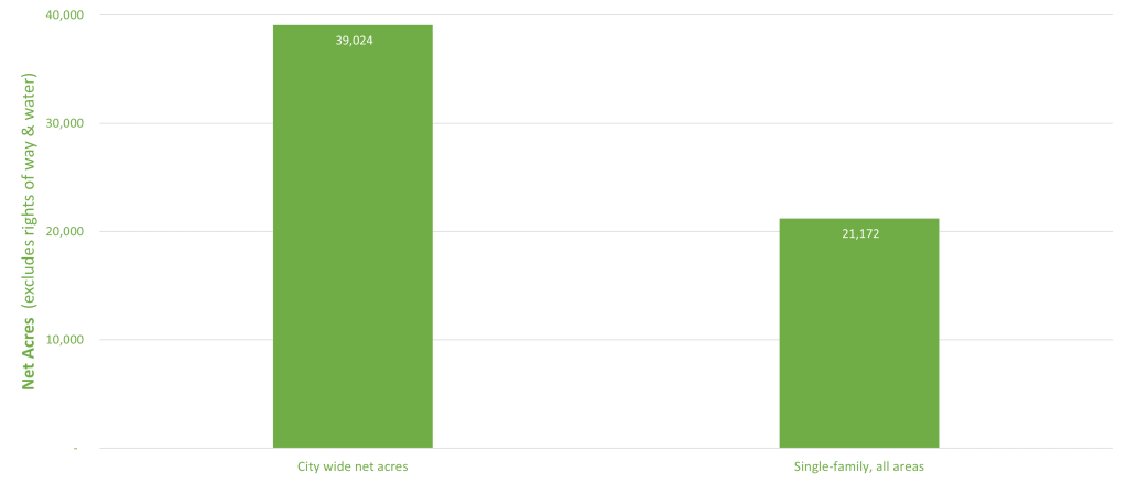
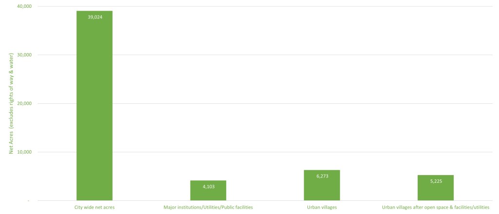
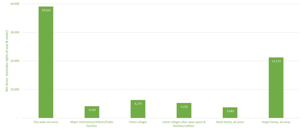
Seattle has 39,024 potentially buildable acres of land. That’s called “net acres” because it takes out water and rights-of-way like roads. Of that, 21,172 was zoned single family on the city’s 2017 future land use map.
This choice to zone a big swath of city land for a form of housing that tends to be occupied by wealthier, Whiter households family might seem to rub up against values of sharing “limited resources and opportunities,” “connections between diverse groups of people,” and “a pathway to employment” (at least without a long commute for those lower on the wage scale.)
By 2019, for example, in the Seattle metropolitan area the median annual income of households in single family detached homes was a whopping 2.1 times that of households living in two to four unit homes: $120,000 versus $56,000, respectively.
But here’s the kicker: this isn’t much of a change from the past. In 1991, the median annual income of households in single family detached homes was 1.8 times that of households living in two to four unit homes: $44,518 versus $24,724, respectively in 1991 dollars.
The ratios are comparable for larger apartments, too.
So one piece of the puzzle is: how could 1990s neighborhood planning process have possibly concluded that constraining by law the amount of land on which homes for people with less rather than more income could be built could be consistent with managing growth “in a way that benefits all of the city’s residents,” as the current published plan claims/ (emphasis added).
So let’s take a deeper look at the much-touted “urban village strategy.” The city claims it “supports the core values” of community, environmental stewardship, economic opportunity and security, and race and social equity by “[d]irecting growth to existing urban centers and villages.”
As a comparative benchmark, there are 4,103 acres citywide occupied by major institutions, utilities, and public facilities. So imagine your experience coming across public schools and City Light facilities, as you’ve moved about the city to get a sense of scale.
There are around 6,300 acres of land in urban villages. But since some of that land is dedicated to institutions, utilities, and public facilities, and some of it is open space, that leaves 5,225 acres available for buildings of all types (residential, commercial, mixed use, and industrial). That’s just 27 percent more land than major institutions, utilities, and public facilities citywide.
On the city’s archived neighborhood planning web page, the claim is made that:
When we set out to write the first neighborhood plans, we asked tough questions. Where would all these people live?
Another piece of the puzzle is how would that lead to the conclusion that “on barely a quarter more land than that occupied by public facilities ” could have been anything but a laughable answer.
One claim we will encounter over and over in its is that the urban village strategy:
…makes it possible for more people to live near job opportunities and near services
that can meet their everyday needs. In this way, more people are able to walk or bike to
some of their daily activities, leading to more activity on the sidewalks and fewer vehicles
on the streets, and making these communities more vibrant. The urban village strategy also
puts more people near transit service so that they can more easily use buses or light rail to
get to other job centers, shopping, or entertainment. This access is useful for all residents,
but particularly those with limited incomes or physical limitations that make them reliant
on public transit.
Except from the get-go it did not. Even within urban villages, land remained zoned single-family, constraining how many people could live in these ostensibly idea locations, and putting up affordability barriers to those who wanted to.
Here’s what the original Wallingford neighborhood plan has to say about retaining single family zoning within the urban village:
2.2 Protect the Character and the Integrity of the Existing Single Family Areas.
2.2.1: It is the intent of the Neighborhood Plan that the City not up zone areas within the
Wallingford Plaming Area which are currently zoned SF (Single Family) whether inside
or outside of the proposed Residential Urban Village.2.2.2 It is the intent of the Neighborhood Plan that the City not change the current
development standards for SF (Single Family) zones whether inside or outside the
Residential Urban Village. Leave the present regulations regarding SF zones as they are
now
Imagine thinking that the prosperity of local business districts and health of the environment would rather have fewer than more customers within walking distance. Imagine people with “limited incomes” that “make the reliant on public transit” would be fully and fairly served by reserving land closest to transit for fewer, more expensive homes.
As a result of plans like these, until recently there was less land zoned for multi-family housing (of all types, large and small) citywide than public institutions–just 3,683 acres.
One might think that after decades to assess and reflect on this disconnect, city policy might have changed. Well, the glass is decidedly no more than half full. In 2017, as part of an inclusionary zoning plan (in which larger buildings can be build in exchange for contributing to affordable housing), 427 acres of single family zoning in urban villages was changed to multifamily.
Here’s the glass “more than half empty,” however: 6,338 acres of city land remained zoned for single family 7,200 or 9,600 square foot minimum lot sizes. (The citywide standard for minimum single family lot size if 5,000 square feet. A majority of single family lots in older neighborhoods like Queen Anne and Wallingford are smaller than 5,000 square feet. The most common zoning in Levittown, the archetypal American suburb, was single family 6,000.)
So here we are: more land is reserved for the most extreme form of housing for the much-more-than-typically affluent, the least pedestrian-friendly, most auto-dependent, and least amenable to local business districts than the land available for multifamily housing citywide, and the urban villages.

If this seems like a strong indication that the process and the plan was not executed for the benefit of “all” city residents, and that it is inconsistent with the values supposedly guiding it–you’d be right.
In the next of this series we’ll look at the biggest tell of them all, and the real values and motivations hidden (well, often not) behind the scenes.
